

 Shopping cart: 0
 |
|
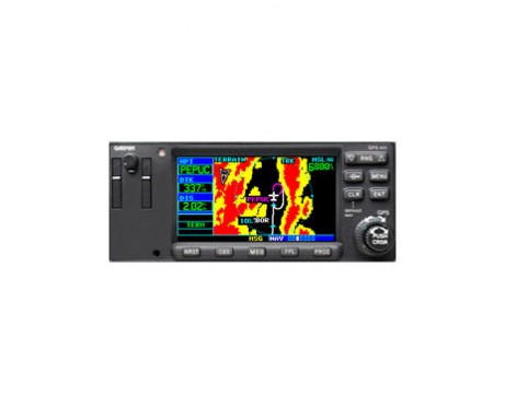

The GPS 400W and its larger companion, GPS 500W, provide big-picture situational awareness, WAAS navigation and a host of interface capabilities. GPS 400W is a WAAS-certified GPS with color moving map and includes the popular features of the GNS 430W — minus the nav and comm.
Fly WAAS Approaches
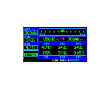
GPS 400W comes with built-in WAAS navigation capabilities. It is approved to fly LPV “glideslope” approaches without reference to ground-based navaids of any kind. Featuring an advanced 15-channel receiver capable of five position updates per second, GPS 400W meets the FAA's stringent TSO C146a standards for WAAS "sole means" navigation — providing vertical and lateral approach guidance into thousands of U.S. airports previously inaccessible in IFR conditions.
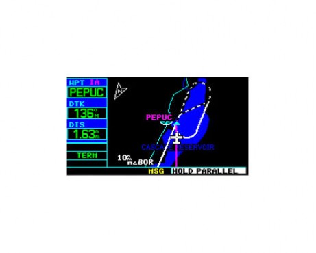
Get High-Resolution Mapping
GPS 400W's 4-inch high-contrast display with brilliant colors makes it easy to read and interpret pilot-critical information. Effective use of color makes it easy to see your position relative to ground features, chart data, navaids, flight plan routings, approach procedures and more. Conveniently scan information from wide viewing angles, even in direct sunlight.
Enhance Situational Awareness
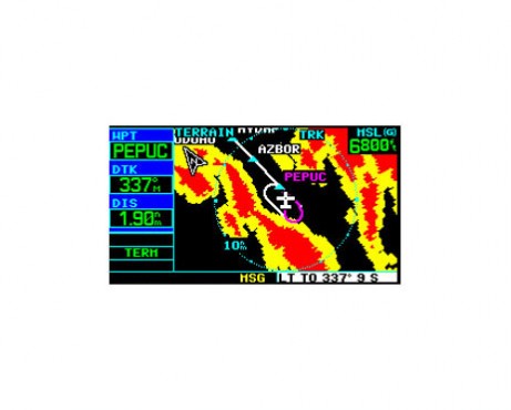
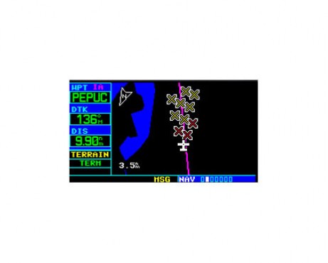
GPS 400W seamlessly integrates built-in terrain and navigation databases, providing a clear, concise picture of where you are and where you’re heading. The 400W's huge Jeppesen® database, updated with front-loading data cards, contains location reference for all airports, VORs, NDBs, Intersections, Flight Service Stations, published approaches, SIDs/STARs, Special Use Airspace and geopolitical boundaries. A detailed basemap clearly shows airports, cities, highways, railroads, rivers, lakes, coastlines and more. Using information from the built-in terrain and U.S. obstacles databases, the 400W displays color coding to graphically alert you when proximity conflicts loom ahead.
Operate with Ease
GPS 400W is one smart box that is simple to operate. Thanks to intuitive software, logical page design and efficient knob layout, this unit makes so much information easy to use. Its user-configurable display simplifies access to massive amounts of pilot-specific data.
Expand Your Panel Mount
GPS 400W is easy to interface with a wide array of optional sensors and tracking systems, allowing you to see and avoid hazards such as threatening weather, lightning or air traffic. With an optional subscription to XM WX Satellite Weather™ and the addition of the GDL 69 or 69A datalink receiver, you’ll have access to up-to-the-minute, high resolution weather for the U.S., right in the cockpit. Information includes NEXRAD, METARs, TAFs, lightning and more and can be laid directly over Jeppesen and topographic map databases. With an additional monthly service fee, GDL 69A delivers XM Satellite Radio to your aircraft. Add the Garmin GTX 330 Mode S transponder, and GPS 400 will also display Traffic Information Services (TIS) alerts that identify surrounding air traffic.
Delivery package
- GPS 400W receiver, TSO-certified to C146a, GAMMA 3
- Basemap: Worldwide Land
- Jeppesen datacard
- TAWS/Terrain datacard
- TSO GPS antenna
- Installation kit
- Pilot's guide
- Quick reference guide
Specification
Physical & Performance: |
|
| Unit dimensions, WxHxD: | 6.25"W x 2.65"H x 11.0"D (15.9 x 6.7 x 27.9 cm) |
| Display size, WxH: | 3.3"W x 1.8"H (8.4 x 4.6 cm) |
| Display resolution, WxH: | 240 x 128 pixels |
| Display type: | 8 color DSTN LCD |
| Weight: | 4.9 lb (2.2 kg) |
| Voltage range: | 11-33 |
| Built-in VHF Comm: | no |
| Transmit power: | no (VHF comm not included) |
| Built-in VOR/Loc/Glideslope: | no |
| Receiver: | 12 channel |
| IFR or VFR: | IFR |
Maps, Databases & Memory: |
|
| Basemap: | yes |
| U.S. Terrain and Obstacles database: | yes |
| Navigation database (includes Jeppesen® data): | yes |
| Types of Jeppesen data: | full and non-precision approaches, DPs and STARs |
| Navigation database coverage areas: | Americas, International or Worldwide |
| Waypoints/favorites/locations: | 1,000 |
| Flight plans: | 20 reversible; up to 31 waypoints each |
Features: |
|
| Fly WAAS approaches: | yes |
| Moving map: | yes |
| Front-loading datacards (conveniently update database information): | yes |
| XM WX Weather & Radio for U.S. & Canada compatible: | yes |
| Traffic Information Services (TIS) alerts compatible: | yes |
| Class B TAWs alerting compatible: | no |


")
