

 Shopping cart: 0
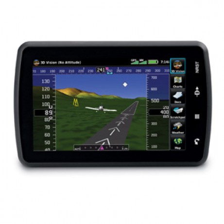
|
|
Aera 795 Garmin - review of the best GPS for aviation. Outstanding 3D GPS navigation for sale
User Reviews and Overview Aera 795
Air navigation with Aera 795 Garmin is safe with its detailed mapping and forward-looking terrain avoidance capability. This handheld portable aircraft GPS has a touchscreen interface and a robust document viewer. A top-down view of the entire route with the 3D map navigation can enhance the situational awareness.Avid users of Aera 795 Garmin shares their review about the product, a user said that this is the best gps for ultralight aircraft, and has an easy to use functions. Another user gave a tip that a used garmin aviation gps for sale is great and recommended, but it should be in a decent price.
Keep your hands free from paper charts.
Aera 795 fullfills the role of either a Class I or Class II electronic flight bag, greatly reducing the need to rely on paper charts in the cockpit. Initial georeferenced VFR sectional and IRF enroute charts come preloaded that show your aircraft’s position overlaid directly on the relevant chart. When in IFR map mode, the 795 can display victor airways, jet routes, minimum enroute altitudes and leg distance, much like what’s found on traditional enroute charts. Initial georeferenced Garmin FliteCharts provide approach charts and airport diagrams for the U.S., while pilots who prefer Jeppesen charts and diagrams can use optional Garmin ChartView service, which utilizes Jeppesen’s extensive library to provide global georeferenced charting capabilities. aera 795 also includes a robust document viewer, so you can easily pull up weights and balances, flight manuals, raster charts or a variety of electronically formatted materials you download to the device. A “scratch pad” feature also allows you to quickly jot down clearances and other pertinent notes while en route, while a checklist viewer allows you to create customized and interactive electronic checklists.
Awareness in any situation: 3D Vision mode, AOPA Airport Directory Data, SafeTaxi®.
Aera 795’s built-in terrain and obstacle database not only shows contours in 3D Vision mode, but also allows for a top-down view of your entire route. To help you navigate around unfamiliar airports, SafeTaxi® provides detailed taxiway diagrams and position information for many U.S., European or Canadian airports, while a private airport and heliport database greatly expands your emergency “nearest” options. FBO, ground transportation, lodging and other facility information for most U.S. airports are also available through preloaded AOPA Airport Directory Data; international pilots may choose to opt for global AC-U-KWIK airport directory data instead.
Great opportunities for expanding the navigator. Update, manage and purchase the latest aviation data.
With 2 serial ports, Aera 795 allows for simultaneous connectivity with other hardware. With an optional GTX 330 Mode S Transponder Interface, you can access Traffic Information Service (TIS) alerts, where available, right on the device while also sending frequencies to a SL30/40 radio or relaying position reports to other devices. By adding optional City Navigator maps, both helicopter and fixed-wing pilots add street addresses as waypoints or direct-to destinations. The device includes an SD™ card slot for easy updates and expansions; update, manage and purchase the latest aviation data for your aera through flyGarmin.Delivery package.
What you get when buying Aera 795:- aera 795
- Yoke mount
- DC cigarette adapter 12/24 volt cradle
- Home A/C cradle dock
- GA 25 remote antenna with suction cup mount
- USB cable
- Carrying case
- Touchscreen cleaning cloth
- Quick reference guide
- Complimentary single database update
- Pilot's Guide e-version (viewable on the document viewer)
Specs.
| General | |
| Physical dimensions | |
| Weight | 26.4 ounces (748 g) with battery pack; 18.3 ounces (519 g) without battery pack; 12.7 ounces (361 g) RAM mount |
| Battery type | rechargeable, replaceable Lithium-ion |
| Display type | dual-oriented, bright, color WVGA TFT with adjustable backlighting and selectable screen orientation |
| Display size | |
| Display resolution | 480 x 800 pixels |
| Battery life | up to 3 hours with full backlight and GXM 40 connected (8 hours with 50% backlighting and XM connected) |
| Memory/history | internal solid state |
| IFR or VFR | VFR |
| Maps & Memory | |
| Basemap | Yes |
| Ability to add maps | Yes |
| Accepts data cards | yes (SD cards) |
| Waypoints/favorites/locations | 3 |
| Routes | 50 |
| Databases | |
| Navigation database (includes Jeppesen® data) | Yes |
| Navigation database coverage areas | Americas |
| Types of Jeppesen data | full and ARTCC, FSS frequencies and final approach waypoints |
| Preloaded Terrain database | Yes |
| Preloaded Obstacle database | Yes (U.S. and Europe only) |
| Preloaded SafeTaxi™ airport diagrams | Yes (U.S. only) |
| Preloaded AOPA Airport Directory | Yes (U.S. only) |
| Preloaded Garmin FliteCharts® | Yes (U.S. only) |
| Preloaded low & high altitude enroute airways | Yes |
| Preloaded private airports | Yes (U.S. only) |
| Aviation Portable Features | |
| Moving map | Yes |
| Patented panel page | Yes |
| HSI (GPS-based) | Yes |
| IFR map mode | Yes |
| Audible terrain alerts | Yes |
| Terrain resolution | standard |
| Smart Airspace Feature (generates and displays altitude-sensitive alerts) | Yes |
| Automatic logbook | Yes |
| Separate serial and USB interfaces | Yes |
| Additional | |
| Additional | GPS receiver has a nominal operating velocity range of 0 – 800 kts (411 m/s) |
- 3-D Navigation with MFD and EFB Capability
- 3D Vision perspective view
- 7" sunlight-readable touchscreen
- Fast 5 Hz GPS refresh rate
- Robust georeferenced charting options
- Document viewer and scratchpad
Related goods and services


