

 Shopping cart: 0
 |
|
|
Synthetic Vision Technology (SVT) for G600/G500
At last, there’s an easy way to upgrade your current aircraft with Garmin’s state-of-the-art SVT™ synthetic vision technology. Because now, a special scaled version of SVT is available with Garmin’s G600 and G500 retrofit flight display systems. This safety-enhancing 3-D “virtual reality” capability comes as standard on the G600; optional on the G500. And it promises to change the way GA pilots visualize flight operations from now on.Fly with a Whole New Perspective
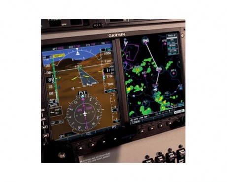
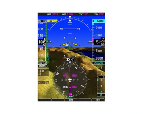
Designed to make situational orientation easier and less stressful, Garmin SVT uses sophisticated graphics modeling to recreate a visual topographic landscape from your system’s terrain-alerting database. The resulting 3-D display provides you with a lifelike depiction of ground and water features, airports, obstacles and traffic – all shown in relative proximity to your aircraft. So, instead of a flat blue-over-brown attitude/heading reference, you’ll now see an in-depth perspective view of realistic terrain features rising into the sky. It’s like looking “through” the PFD to monitor your flight situation on a cloud-free, view-to-the-horizon backdrop.
One Bezel. Two Screens. 3-D Vision
Integrated with the G600/G500 primary flight display (PFD), Garmin SVT is a virtual revolution in “big picture” visualization. It’s a scaled version of the same technology featured on our industry-leading G1000® glass cockpit systems. And it can make a world of difference in the way you navigate today’s busy airspace.
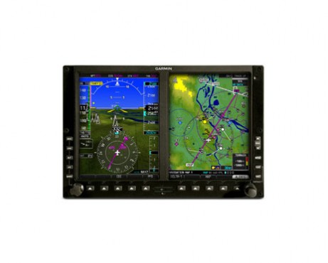
In the G600/G500 retrofit configuration, all primary flight, navigation and sensor data are consolidated within one 10-inch wide bezel containing dual 6.5-inch LCD displays. The unit fits neatly into the panel space previously occupied by your standard “six-pack” of 3-inch mechanical flight instruments. And both the Primary Flight Display (PFD) and Multifunction Display (MFD) are paired side-by-side directly in your field of view – for faster scanning and improved situational reference.
Turn Data into Awareness
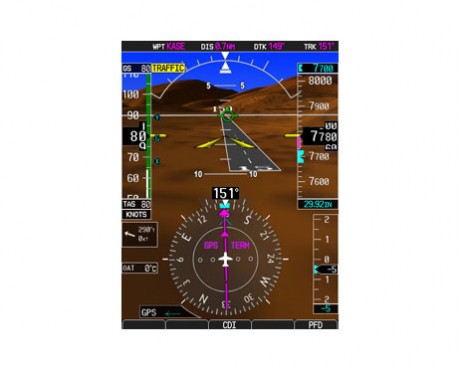
When you add SVT to the mix, your visual frame of reference gets even better. In addition to identifying airports by name and showing runways (with their numbers and threshold markings) in graphical perspective, the SVT display lets you see at a glance nearby terrain features or obstacles that might pose a hazard to navigation. Although not intended to replace traditional attitude and directional cues as one’s primary flight reference, SVT clearly improves your view of this data by giving it a realistic visual frame of reference. So, it’s almost like having a clear-day “out-the-window” view of your flight situation – even in solid IFR or nighttime/marginal VFR conditions.
Red Alert? Look out Below
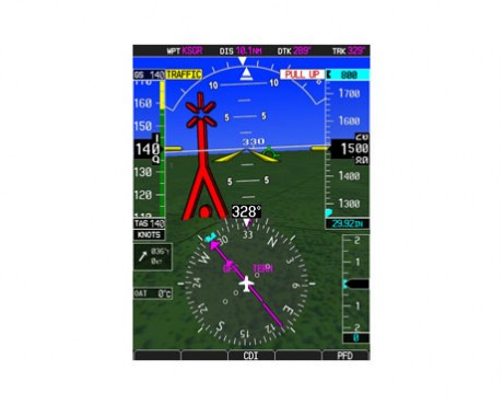
As you scan out across the virtual landscape, Garmin SVT helps put everything in context – while color-coding surfaces where potential flight-into-terrain risks exist. SVT uses its terrain-alerting database to clearly show with amber or red overlays those areas you need to watch. What’s more, any towers or obstacles that may encroach upon the flight path are color-highlighted and clearly displayed with height-appropriate symbology.
Helps Watch for Traffic, too
In addition to fixed terrain and obstacles, SVT also works with TCAS/TAS/TIS traffic technologies to depict targets in 3-D perspective, so you can visually gauge how high and how close they are. The proximity-coded TCAS symbology grows larger as it gets nearer – making traffic conflicts easier to see and identify.
The Future Flies with SVT
It takes perspective to be a good pilot. And with Garmin SVT, you’ve got an edge where it really counts. Terrain features, traffic, towers, obstacles, waterways, airports and more: Your “big picture” flight situation has never been easier to grasp. Sunny or cloudy. Blue skies or gray. Day or night. With Garmin SVT, you’re always flying with the future clearly in sight.


