

 Shopping cart: 0
 |
|
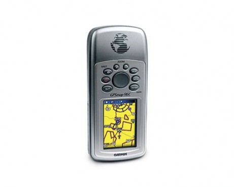

The portable color GPSMAP 96C combine a pilot-friendly operating system with powerful navigation features.
User reviews and overview GPSMAP 96C
GPS tracking for aircraft is essential for situational awareness and safe flights, GPSMAP 96C is a grayscale and pilot friendly navigation systems. With its highly accurate GPS, it has been widely used for GPS for ultralight aircraft. The portable color GPSMAP 96C along with the grayscale GPSMAP 96 combine a pilot-friendly operating system with powerful navigation features and great value — giving you the freedom to go anywhere.The portable color GPSMAP 96C along with the grayscale GPSMAP 96 combine a pilot-friendly operating system with powerful navigation features and great value — giving you the freedom to go anywhere.
Jeppesen database
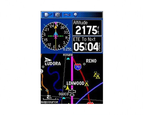
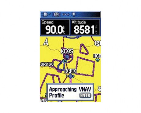
GPSMAP 96C offers a built-in Jeppesen® database and a U.S. database of obstacles, for the ultimate in situational awareness. View Jeppesen airport data overlaid on a map and receive alerts when potential obstacles loom ahead. In addition, the 96C shows localizer-like runway extensions and graphic HSI steering with GPS-derived VNAV for added orientation.Handheld GPS Receiver
GPSMAP 96C features a bright sunlight-readable color display that makes map detail easy to read. Its simple keypad and streamlined design literally put the world of GPS capability in the palm of your hand.FlightBook
A built-in logbook tracks your flying hours and automatically records departure and arrival locations. When used with Garmin's free logbook software, FlightBook, you can simplify your record keeping by creating, managing, analyzing, saving and printing flight data from the GPSMAP 96C's logbook.3 Navigation Modes
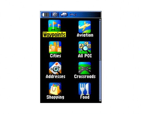
GPSMAP 96C's three navigation modes and built-in autorouting basemap let you go from plane to car to boat to hiking boots without missing a beat. With 119 megabytes of memory and a mini USB port, you can quickly download and store map data from a variety of optional MapSource® products. Add detailed street maps for street navigation. Or, for a great day on the water, customize the water resistant 96C with marine cartography. The 96C also operates on 2 AA batteries, making it easy to use on foot.Delivery package.
What you get when buying GPSMAP 96C:- GPSMAP 96C
- One basemap below:
- Americas Lite Routable basemap
- Atlantic Lite Routable basemap
- Pacific Lite Routable basemap
- MapSource® Trip & Waypoint Manager software
- Yoke mount
- Wrist strap
- USB cable
- 12-volt adapter
- Two AA batteries
- Owner's manual
- Quick reference guide
Specs.
| General | |
| Physical dimensions | |
| Weight | 7.6 ounces (215 g) |
| Battery type | two "AA" batteries |
| Display type | 256 color transflective TFT |
| Display size | 1.5"W x 2.2"H (3.8 x 5.6 cm) |
| Display resolution | 160 x 240 pixels |
| Battery life | up to 40 hours (in battery save mode) |
| Memory/history | 119 MB |
| IFR or VFR | VFR |
| Maps & Memory | |
| Basemap | y |
| Ability to add maps | y |
| Waypoints/favorites/locations | 1 |
| Routes | 50 |
| Databases | |
| Navigation database (includes Jeppesen® data) | y |
| Navigation database coverage areas | Americas, Atlantic International or Pacific International |
| Types of Jeppesen data | full + ARTCC, FSS frequencies and final approach waypoints |
| Preloaded Obstacle database | y |
| Aviation Portable Features | |
| Moving map | y |
| HSI (GPS-based) | y |
| Terrain resolution | not available |
| Automatic logbook | y |
| Separate serial and USB interfaces | y |
Related goods and services


